Blue Ridge Parkway—Virginia & North Carolina
Interactive Map
Planning Tips
The interactive map only contains the national park campgrounds along the route. There are many others near the parkway
Traveling the Blue Ridge Parkway is an excellent way to tie together multiple other destinations. See the Destinations Map to help with more substantial planning.
There are too many options for a comprehensive list of service and entertainment options. At a minimum, it will be necessary to exit the parkway for fuel. Some larger municipalities along the way are Roanoke, Fancy Gap and Boone, but a look at the map will reveal other possibilities.
Highlights
The Blue Ridge Parkway runs 469 miles (755 km) between the Shenandoah and Great Smoky Mountains National Parks. Winding along ridgelines and through valleys, this All American Road is renowned for its beauty.
As a long, linear park this roadway is fully self contained its own collection of national park campgrounds, trailheads, scenic pullouts and managed historic sites. Information centers are located along the route. Entry and exit points also allow travelers access to towns and points of interest near the parkway.
This route remains largely unspoiled and grants access to some of the most beautiful spaces in the Eastern United States.
Video
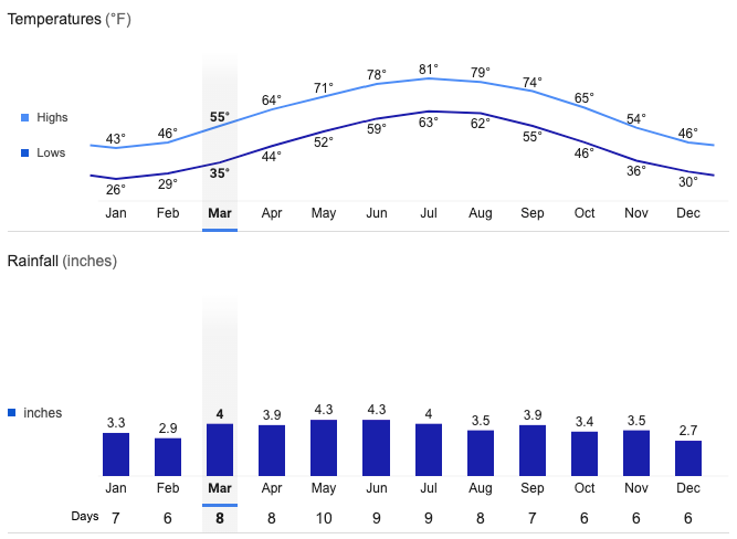
Fancy Gap Average Temperatures and Rainfall